Wednesday, 26 December 2007

Wansfell Pike

26th December 2007

Full waterproof gear for the start today, very wet in Ambleside. The plan is to walk over Wansfell pike to Troutbeck and return skirting the southerly aspect of Wansfell.
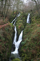
From the town centre take the road at the back of the Salutation Hotel up the R hand side of Stockghill force, soon entering the woods for a pleasant ascent up the ghyll bank to the waterfall which was quite impressive with all the recent rainfall.
Near the top of the waterfall a very distinct path turns right to take you out of the wood back to the road, which you take up to the left, throuh the farm gate and soon over a stile on the right heading up the hill, with a heard of cattle in the field guarding the stile. (This should not be relied on as a reliable landmark!).
The path is well made all the way to the top so route finding is not a problem. We were not worried about this as today we were accompanied by my daiughter and her boyfriend, a member of the Mountain Rescue team in Northumberland. During the ascent keep turning round to admire the view over Ambleside to the fells beyond, although today all the mountain ranges were shrouded in mist.
Althought the rain had stopped by now, the biting cold wind got stonger and we were glad to have our waterpoofs. A possibilty on reaching the summit was to walk along the ridge to it's highest point at Baystones but the weather and the promise of a warm, Boxing Day pub lunch was too much to resist and we continued east from the summit, keeping to the path eventually through a gate in a wall accessing a track leading down to the right, to Troutbeck.
We were planning on walking to The Queens Head but ended up in The Mortal Man just a few hundred yards to the left once reaching the road at Troutbeck.
Refreshed after a pint and a hearty lunch we retraced our steps passed the track leading down from the fell. Half a mile further along the road, at the post office bear right up the hill signposted Robin Lane. This road, then track, contours around the south end of a spur. Be careful at a junction of paths to take the track through the gate to the left signposted Jenkin Crag, otherwise you will end up back on the eastern slopes of Wansfell.
The path dips down and then up to High Skelghyll Farm, through the woods, on to Jenkin Crag and the contonues to Ambleside, the bright lights of Heyes Garden centre catching the eye in the distance in the dull, misty afternoon.

Time for walk 4hrs (not sure how long we had in the pub!)
Grading Excellent Boxing day walk

Memories Stockghyll force full of water
Pub Lunch
Sharing the walk with Claire and John

Completed 22 To Go 192
Friday, 9 November 2007

Helm Crag, Gibsons Knott, Calf Crag and Steel Fell

Another cloudy but dry day, couldn't really predict what the weather had in store for us today.
We ascended Helm Crag from the Greenburn valley. Having taken the path from Easdale many times, a lovely ascent in its own right, our aim today was the 'Greenburn round', so decided on the alternative climb up. At Ghyll Foot take the road up to the gate as though heading for Steel Fell. Through the gate rather than taking the path up Steel Fell (our way down), follow the river a short distance to a footbridge. Crossing the bridge it is then more or less straight up to the col beneath the top. A steep grassy climb but soon over with a welcome rest before turning left up to Helm Crag. We didn't climb the summit rock slab (not wanting to make fools of ourselves with other people around).
The ridge ahead, looking over the col we had just come up from, is text book Lakeland scenery. The sun was out and a gently undulating moorland ridge extended into the distance with the higher fells of Ullscarf and Greenup Edge beyond. Soon back down to the col and then a good path keeping mainly to the Far Easdale side, took us over Gibson Knot and several other nobbles until eventually on to Calf Crag at the end of the ridge. Most folk who were up on the fell left the crag to the west heading for the head of Far Easdale to take the long path down to Grasmere. We left this path a few hundred metres after Calf Crag and headed north across boggy moorland until finding the rusty posts of an old fence which we followed in a north easterly direction all the way up to Steel Fell.
This section requires some nifty navigational skills if in mist, from personal experience. Our previous walk here was in mist and we passed a group of walkers, who we later learnt were form a walking club in Yorkshire but unfortunately descended by mistake into Wythburn and ended up walking along the main road to the Traveller's rest where, by chance, we met back up with them to hear their woes and moans targeted at the leader.
After a while an indistinct path appeared which eventually turned into a good but boggy path to follow. With the Helm Crag Calf Crag ridge now slightly below us on our right the view south was amazing. The appearance was of three or four ridges shooting out from the central higher fells, one behind the other: Gibson Knot, Blea Rigg, Lingmoor Fell, Wetherlam and in the distance Coniston Old Man. Looking north across Thirlmere, Skidaw and Blencathra were dappled with sunlight.

The way down form Steel Fell was straight down the South East ridge directly to Ghyll Foot, the traffic noise from Dumail Raise increasing as the altitude decreased.
The sun stayed out most of the day, incredibly warm for mid November.
Time 4 hr 30mns
Grade Excellent
Memories Walking up to Steel Fell with the extensive views to the right
Completed 21 To Go 193


Wednesday, 7 November 2007

High Rigg

7th November 2007


Do not be deceived by this excellent ‘mini mountain’. A hill that is often driven by without further thought either on the 591 grom Grasmere to Keswick or taking the short cut from the A591 to the A66 at Thirlspot. So, a short walk across its ridge for an afternoon stroll, was the idea behind today's walk.
Parked at Legburthwaite car park and crossing the river via the bridge carrying the main road, immediately took the stile over the wall on the right. Straight into woodland and heading up the crest of the ridge. The path is easy to follow, quite steep in places but soon at the top seeing the ridge open northwards in front of your eyes. This is why it pays to look at the map properly, not because route finding is difficult – a lovely easy to follow path along the whole ridge, but more to determine where the actual summit is! After several exclamations that ‘we are at the top’ (combined with the now expected kiss as reward completing another Wainwright), I soon realised that this was no short stroll. The final summit is actually at the far end of the ridge after about one and a half miles of undulations. Having said this, the experience was delightful, with the feeling of being on the high fells, whist only at a height of around 300m.
The main path is easy to follow along the traverse and many of the ‘summits’ can be avoided by skirting round (unless you think they are the actual summit and have to climb them all).
All along the ridge there are fine views over to Blencathra, today in and out of mist but glorious colours with the low afternoon sun on its slopes. Looking south the vista extended along Thirlmere to Steel Fell.
The path down to The church of St Johns in the Vale was obvious, a steep grassy descent to the road. We were able to look inside the picturesque little church before descending the road and soon taking the bridleway to the right skirting the western side of High Rigg to enjoy a beautiful lower valley walk back to the car, commencing and finishing in woodland, the latter stages along the banks of St John’s Beck

Time 3 hrs

Grade Excellent

Memories Longer than anticipated
A fine 'mini fell'


Completed 17 To Go 197

Monday, 5 November 2007

Sale Fell and Whinlatter (Two seperate walks)

5th November 2007

Two separate walks today.

Set off from our base in Staveley with low cloud rain and wind. As we headed north up the A591 the showers became heavier and more prolonged. A short walk up Sale Fell seemed ideal then to a cosy tea shop in Kewick.
Parked near the small St Margarets Church on the road between the Pheasant Inn and Wythop Mill. The rain stopped as we got out of the car but we donned full waterproofs in preparation. Left the butties in the car as we weren’t planning being out in the rain for too long. Took the path signposted to Kelswick up to a wall on the fell then turned left to contour round. Best to keep to the lower paths rather than heading up too soon into the disused Quarry. The weather brightened as we turned south by the woods and soon we were stripping off our layers wondering where the rain had gone. On reaching a gate in a wall we headed upwards keeping the wall on out left until noticing a direct grassy path up to the summit. Still sunny but no clear views in the distance. However looking down into Wythop Beck and across to Ling Fell was a peaceful unspoilt valley, an area of the Lake District new to us and probably one we would not have visited but for our decision to walk the Wainwright summits.
Took the obvious grassy track south off the summit back to the wall we had previously left and followed it down to Kelswick farm with the beautiful valley below us. A contour round Dodd crag soon took us back to the car, unbelievably still in fine weather. As soon as we opened our sandwiches in the car, the rain came lashing down again – couldn’t believe our luck.

The weather improved again as we started to head south back to Keswick. A decision to be made; either another walk in the afternoon to Whinlatter, or a visit to Keswick to browse more ‘crap shops’. Here I have to explain the terminology ‘crap shop’. This is a name we have given to all the shops around the tourist centres of the Lakes and elsewhere, bulging with items labelled as' crafts', which are of absolutely no use to anyone and are obviously mass produced as they appear time and time again. They are sold in shops which also sell soaps, candles etc the smell of which overpower anyone who enters the shop.
Fortunately, the former option won the day and we drove up to the top of Whinlatter pass and followed Wainwrght’s route, very well illustrated, through the forest taking the second turning on the left from the initial forest path to the forest boundary. Then over a stile and steeply right up the hill then left along the top to the summit. Walking up the forest road we were fortunate to see a Roe deer bound across the track a few yards in front of us.
Wonderful views across to Grisedale Pike, the distinctive Causey Pike and the peaks extending from it. The weather now fine with most of the tops out of the mist.
Returned by the same route and treated ourselves to tea at the Whinlatter centre.

Time Sale Fell One hour 15 minutes
Whinlatter One hour 30 minutes

Grade Excellent for both short walks

Memories Extremely lucky with the weather

Completed 16 To Go 198

Saturday, 3 November 2007

Pike O’Blisco and Cold Pike

3rd November 2007


Sheep on Wrynose pass


Parked half way up the Wrynose Pass at Wrynose Beck. The path up Pike O’Blisco is clearly shown on the OS map but in practice is very indistinct and in places, nonexistent. Starting off up the L hand bank of Wrynose beck, the ‘path’ rises high above the beck and continues to the keeping to the left bank of the gills running down from the fell. (i.e not crossing any stream). If the path is lost, just head up across the heather and bracken in a north westerly direction. Very tiring walking but then a path, or sheep track, will appear and all is well again until this fades away and back to the slog through bracken. Eventually the summit is in view with the crags of Black Crag away to the left. A very quiet ascent, met nobody until the summit (which was quite busy!).
It really goes without saying, that the views from the summit were awesome, across the Langdale valley to the Pikes and over to the Crinkles and Bowfell at the head of the valley.
Our next peak for the day, Cold Pike, could be seen across the col with Red Tarn sitting at it's base. A good path down to the tarn and straight across, following the main path up towards Crinkle Crags until it crossed a stream when we took a sharp left turn and found a path up to Cold Pike. Cold by name but for the time of year it was very mild. By mid afternoon the weak sun was beginning to set, silhouetting the smaller fells and valleys in the south west with an autumnal misty haze. Beautiful.
The way down took us over a couple of rocky nodules on the summit rige of cold pike and then found a small but easy to follow path down the south east ridge. This didn't seem to accurately follow the route of the path on the OS map, keeping on the ridge longer before descending left to the valley. Eventually we joined the main path from red tarn just before reaching the road at the top of the Wrynose Pass.

Time 3hrs 45minutes

Grade Excellent

Memories Lack of path despite being clearly shown on OS map
Autumnal views from Cold Pike across to Harter Fell and beyond


Completed 14 To Go 200

Friday, 2 November 2007

Loughrigg Fell

2nd November 2007

What can I say about Loughrigg! A delightful short hill walk with extensive views all around. We have climbed this hill on many occasions, never tiring of the experience. Today we were accompanied by my brother, sister in law and nephew. We took our usual tried and tested route.
Park at White Moss car park (on the right heading towards Grassmere). Immediately across the main road a path descends toward the river and White Moss wood. The river is crossed by a substantial, but narrow, wooden bridge and the path meanders up through the wood up to a kissing gate. Unfortunately this part of the walk is usually far to busy with other folk to take full advantage of gate's description.
Through the gate a path leads left down to Rydal Water and one to the right to Loughrigg terrace (our route back). Straight on, however is our route contouring round the lower slopes of the fell to the large cave, the entrance recently fenced off because of the dangers of falling rocks. A path heads upwards to the left of the cave ascending the right hand side of the gully. Height is soon gained and the views over Rydal water and the valley to the Fairfield range become more and more impressive. It is better to take a right and fork in the path at one point to avoid boggy ground higher up. After the initial steepish ascent the path levels for a few hundred yards across wet ground but the way ahead is seen ascending steeply up to the summit plateau. This is soon reached and after a short stroll round the corner, the summit cairn is visible with the vista over the Langdale Pikes, Bowfell and Crinckle Crags opening up before your eyes. (Assuming they are not all in mist!).
The way down is north west down the steep main path which leads to Loughrigg Terrace. I prefer to descend this way as the view across Grasmere Lake to the village and the fells beyond, constantly holds the gaze.
Once down to the terrace turn right for a delightful walk back to the kissing gate encountered on the ascent. Take care on the terrace as there is a danger of being mown down by mountain bikers or runners running with full packs!


Autumn in White Moss Wood


Time 2 hours 20 minutes

Memories Autumnal colours looking down on White Moss Wood

Grading Excellent


Completed 12 To Go 202

Wednesday, 31 October 2007

Glenridding Dodd and Sheffield Pike

31st October 2007

Started the walk at Glenridding after a coffee at the guesthouse by the car park. Must try and get out of this habit of having a drink before the walk! (especially as it was instant Latte and disgusting!) The path looks quite clear on the OS map, heading up east of Blaes crag then contouring round and up to the col between Glenridding Dodd and Shefield Pike. However, as usual, the most difficult part of navigation for any walk is the start – finding the path! Today the route was blocked by a gate with an old notice saying ‘No Path’ but could we find another way to get on to the fell? So, over the gate we went quickly up the field to a gate in the wall above, working out excuses we would use if the farmer came following us with a shot gun. (Wainwright does say that some degree of minor trespass may be needed).
The path up was indistinct steep and difficult, not helped by moans of “This can’t be the right way” coming from behind! However we soon found the real path contouring round and up to the col. From hereon the walk was a delight. When looking down it appeared that the path up was the west of Blades Crag. On reaching the col with a gate in the wall, the way up to Glenridding Dodd was easy, following the wall a short way up to the right and as the main path headed down to Mosedale Beck, taking the right hand up to the summit.
From here the route up the south west ridge of Sheffield Pike looked steep rocky and pathless, but after a little gentle persuasion it was decided that would be the route of ascent. We lingered on the Dodd for a while, admiring the beauty and diversity of the scenery all around. The different golds, reds, browns of the trees and bracken, the dark foreboding clouds lingering over the Helvellyn range, patchy beams of sunlight lighting up the lush green in the valley and Place Fell, which today, looked dark and ominous.
Retracing our steps to the col the route up to Heron Crag on Sheffield Pike was a dream. The path was clear all the way, not what we has excepted, keeping mainly to the south side of the ridge above Glenridding Screes, at no time difficult but always with was the dark, even black, clouds over Helvellyn and Catstye Cam ahead. Looking behind, Ullswater extended into the distance like a large figure two. Perhaps the BBC could use this for their BBC2 logo.
The wind, which was quite high at the col was getting stronger and stronger and by the time we reached the summit plateau it was blowing a gale. This coincided with a dramatic change in scenery from a grass/ rocky ridge ascent, to a boggy expanse of moorland (time for gaiters) with our summit not yet in view . Struggling across the bog on a well defined path and against the ever strengthening wind the summit cairn appeared and below it a small stone shelter, a welcome place for lunch.
The route down was straight forward, west off the summit to Nick Head. We had decided to descend via Glencoyne rather than down by the old mines to Glenridding. A much recommended route, the expanse of Ullswater constantly filling the panorama ahead.


Once down to the wall we stayed high above it, heading through the woods, rather than descending to the valley floor. Yet another completely different atmosphere from that we had experience in the day. A carpet of golden fallen leaves on the path, autumnal trees and no wind. Place Fell across the valley now looked gorgeous and welcoming in the late afternoon sunlight.
Once at the road we were able to follow the path on the lake side, only requiring a short section of road walking back to the car.

Time 4hrs

Memories Problems getting on to the hill to start
Wide variety of scenery
High winds on the summit

Grading Excellent

Completed 11 To Go 203

Wednesday, 3 October 2007

Holme Fell

Saturday 29/9/07

Managed to park at the National Trust car park on the A593 near Yew Tree Farm with a path leading up to Tarn Hows heading east. However, crossing the small bridge to the south and across a field takes you easily to Yew Tree Farm without having to walk down the road. From Yew Tree farm the path heads to the right of the farm, through a gate and easily followed north contouring along the eastern slopes of Holme Fell. Always looking for the path which will ascend up to the left, on to the fell itself, this is reached in just under 1km, signed on a rock but not very distinctly. However the path rises pleasantly amongst trees and heather to reach the top of the col apparently known as the 'Uskdale Gap'. Wainwright says the summit, Ivy Crag, can be seen when the col is reached but you have to ascend the obvious path to the left a short way before Ivy Crag is visible. Once on the summit, although not very high, the views are, as always, tremendous. It is often said that views from the lesser peaks are just as satisfying, if not more so than those from the higher peaks. Looking across and up to Wetherlam, across to Pike O'Blisco and beyond to Harrison Stickle, the hills have a different outline and demeanour than when seen from higher aspects on the larger fells.
Holme Fell spreads northwards with undulations and tarns. We decided to head north north west heading directly for the first visible tarn (reservoir) and then trying to find the main path heading down towards Holme Ground. We had to meander south west amongst the ferns and heather on indistinct paths, until the main path down was identified. Soon down to a track just above a wall which followed the wall round the southern end of the fell, eventually joining the quiet road leading up to Hodge Close.
Headed back to Yew Tree farm via the fields with Herwick Sheep and Belted Galloway cows. The way is signposted just before the road crosses a bridge and finished a lovely walk with a bowl of hot soup at the farm (sitting ouitside at the end of September!) before returning to the car.
Time: 2 hours

Memories

Lovely shortish walk with magnificant views

Delicious leg of Heardwick lamb purchased at the Yew Tree Farm cafe / shop

Overall Rating Excellent

Completed 9 To Go 205

Coniston Old Man, Brim Fell and Swirl How

Thursday 27/9/07


Started from the village car park, milling with coach loads of school children being organised into groups, no doubt to make an ascent of the mountain. Took the standard path up the Eastern aspect of the Old Man through the old slight quarries. A quick, direct but not very beautiful ascent until reaching Low Water above the quarries, when the walk becomes more more like a hill climb than a slate museum. I expect very interesting for industrial archaeologists, we saw two taking photos of the old workings and mine entrances.

Once above Low Water the ascent up to the final short ridge is steep but once on the ridge, as a lady remarked in a very broad Geordie accent 'You feel like you're on top of the world.' Despite the number of people on top it is obvious why the old man is a popular climb. Views; South, over to Morcambe Bay, West to Sellafield and the sea, North to the central lakeland fells and East over to the Pennines and Yorkshire hills.

North the broad ridge extends majestically north to Brim Fell and in the distance to Swirl How (our next two objectives). West we had good view of Dow Crag where had been a few weeks earlier and had seen nothing!

Despite the clear weather, a biting strong wind cut through us as we traversed the ridge with full windproof clothing, hats and gloves to Swirl How and descended Prison Band. Instead of heading for Wetherlam we continued our descent to Levers Water. The path loof excellent from Prison Band but soon becomes very indistinct, boggy and difficult to follow. However Levers Water is the target.


From Levers Water the road down back on the old mining road which although are easy to follow, are not particularly interesting. Perhaps we should have finished off with Wetherlam, but an excellent day.

Total Time for the walk 5hrs 30mns (by the way I include all stops in my timings)

Memories:

"It's like being on top of the World"

Overall rating Excellent

Completed 8 To Go 206

Place Fell

Tuesday 25/9/07

Parked in Patterdale and had a quick take a way coffee from the general store before setting off across the beck to the base of Place fell. Decided to ascend the western side of the fell initially contouring round on the upper of two parallel paths along Ullswater's east bank. After approx 1km (the Ullswater Hotel is now directly across on the opposite shore ofthe lake) a path ascends diagonally up the hill to the right, initially a little indistinct but soon, obvious to follow. Quite steep in places but, because of this, height is gained very quickly with great views over Ullswater to Glenridding and the hills beyond (Helvellyn in mist).


Lost the path near the top of the steep section but soon found it again following a small stream (which may actually have been the the original path!).
Once levelled out the path divides and we took the right hand path leading up to the west of The Knight and heading directly for the summit. The summit itself is not visible until overcomming at least 2 false summits.

Having not met a sole on the ascent there were a few walkers on the top. The sun came out and we we able sat out the wind for lunch with Wainwright's book number two picking out all the tops we will need to conquer.
Descended on the main path heading south form the summit. No problems down to Boredale Hause and then a sharp right, back down to Patterdale. Thought about taking in Angletarn Pikes but with sun now out on Boredale Hause a sit down and contemlpation of the view was a far better option.


Total time for walk 4hrs 30mns


Memories :
  • View from summit seeing veils of rain to the east and west with dark clouds but keeping dry ourselves.
  • 2 RAF Tornadoes heading for us over Brothers Water the suddenly splitting one heading over Ullswater and the other, almost in touching distance, down Boredale
  • Sitting in sunshine on Boredale Hause

Overall rating: Excellent


Completed 5 To Go 209

Tuesday, 11 September 2007

Stone Arthur, Great Rigg, Fairfield

Date 9/9/07

We manged to complete our planned walk today taking in 3 of Wainwrights tops.

Started at the Swan Hotel Grasmere, taking road up the right of the hotel following the signs to Allcock Tarn. Immediately after the gate onto the fell turning left we followed the wall by the right of the wood. (The path to the right goes to Allcock Tarn) Very steep in places but a recent path has just been laid making it easier than our last time up here. After a stiff climb the path bears right rising more gently across the bracken slopes toward Greenhead Gill. Before reaching the Gill the path turns left heading directly for Stone Arthur. On reaching the ridge a slight detour west is needed to reach the top. Having spent yesterday with Staveley Historical Society we could look down into Greenhead Gill and see the route of the aquaduct taking water from Thirlmere to Manchester.

The weather was extremely hot and sticky in the valley but cold wind met us as we looked down onto Grasmere. Lovely views over valley to Helm Crag but the higher tops in the distance were in cloud. Had the usual conversation - " Shall we buy a B&B and move to the Lakes?" but soon back to reality and retracing our steps continued along the ridge up to Great Rigg, a gentle steady climb.


A patch of sun on Windermere from Great Rigg


Quite cold now, fleeces on and soon into the mist as we headed north for Fairfield. Below us a heard (if that is the correct term) of fellrunners were dashing across the western slopes heading for Grisedale tarn. We saw them again on the summit dashing towards Dove Crag in the mist compasses and maps (and dibbers) in hand.

The shelters on the summit were welcome to get out of the wind and enjoy a crisp butty and flapjack. Fairfield summit in mist can be a little disorientating so a compass bearing helped us head west down the steep eroded descent to Grisedale Tarn. We passed several exhausted looking runners ascending, not sure how miles they had done already but obviously quite considerable.

Took a while to get down to the tarn then an easy descent down the path via Tongue Gill to the main road and back to Grasmere.

Total time for walk 5 hours (same as last week)

Memories

View from Great Rigg just under the cloud level
Change in temperature between the valley and the ridge
Fell runners taking part in the Lakeland mountain trail http://www.ldmta.org.uk/about/index.htm

Overall Rating: Excellent

Completed: 4 To Go 210!

Monday, 3 September 2007

Dow Crag

Date 1/9/07
Hoping to start with 3 tops today, Dow Crag then on to Brim fell and finally Coniston Old Man
Started walk at 11.15 after driving up and a scone and coffee in Coniston. Parked at bottom of Walna Scar road (should have driven up to the car park in hindsight!).
Rain started after 30mns and never stopped until we were nearly down.
1hr hour 15m gentle ascent to Walnar Scar pass. Head north east over Brown Pike (can't miss the path) then a lovely ridge walk over Buck pike and on to Dow Crag. Route finding no problem good path except on summit of Dow Crag which is very rocky (keep to the west). Thick mist all the way no views of the crags or over to the Old Man.
Descended to Goat's Hause now very wet and getting cold so decided to call it a day and descended passed Goats Water back to the Walna Scar road.
Total time for the walk 5 hrs (we are not fell runners!)

Memories:

Looking down on a bright rainbow in a nearby fieldas we ascended from Coniston [forgot my Camera :-( ]
Goats water atmospherically appearing out of the mist as we descended
Parties taking part in a Coniston Challenge (Canoeing, cycling and climbing the Old Man in one day)

Overall rating Excellent despite the weather

Completed: 1 To Go: 213!